The following two diagrams are reproduced from The Canals of the West Midlands
by
Charles Hadfield (1969, 2nd Ed, p199, David & Charles, Newton Abbott UK)
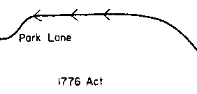
The early locks at Park Lane were replaced by a three lock staircase at Denford, when the Leek branch was built about 1800.
About 1841 the Denford aqueduct was built, part of
the original line was reopened and three new single locks were built as a
replacement for the staircase. Hadfield notes
that the early locks had been 'well spaced' - implying that the present locks
are closer together than the originals.
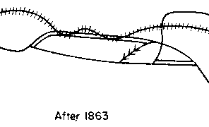 Finally, part of the original line was built on by the railway.
The double lines indicate sections which were abandoned. The right hand set of
these indicate the former staircase locks - part of which are currently used as
a boat mooring (ref 11).
The whole area may be seen viewed from the air in the image below. This is a
composite of several smaller images taken in 2000 and supplied by
www.getmapping.com
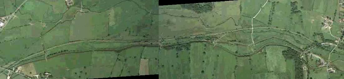
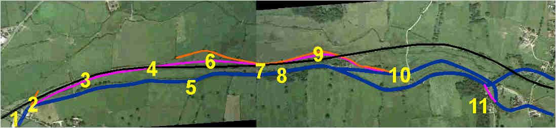
A second copy of this image appears below with all the relevant items indicated.
The relevant maps of the 1st edition Ordnance Survey maps are shown below.
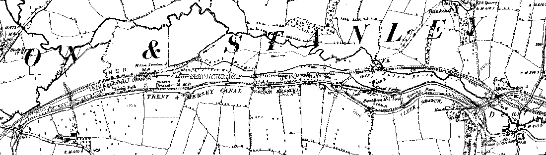
Image produced from the
www.old-maps.co.uk
service with permission of
Landmark Information Group Ltd.
and
Ordnance Survey
Copyright � and/or Database Right Landmark Information Group and Ordnance
Survey Crown Copyright and/or Database Right 2002. All rights reserved.
Careful comparison of the old and new shows many unchanged features. The stream that runs through the valley has obviously been somewhat straightened and additional buildings have appeared - but apart from these factors the valley looks very much now as it would have done 120 years ago.
So what may be seen of the old line now and where did the locks go?
 When I first went and looked at the site with this purpose (and prior to
examing the OS and aerial maps above), I assumed that what appeared to be a
huge winding hole (ref 5 on map) between Park Lane and the current locks would
be a good
candidate for the site of the top lock (see right - looking east). However,
later evidence convinced me
that this was no more than a winding hole put there probably for the benefit of
boats using the stone quarries (ref 8) immediately east of the next bridge and
at
Hazelhurst. Its unusual large size is due to a conveniently sited stream which
enters at its apex (and whose silt has reduced its size considerably) and the
associated lie of the land.
When I first went and looked at the site with this purpose (and prior to
examing the OS and aerial maps above), I assumed that what appeared to be a
huge winding hole (ref 5 on map) between Park Lane and the current locks would
be a good
candidate for the site of the top lock (see right - looking east). However,
later evidence convinced me
that this was no more than a winding hole put there probably for the benefit of
boats using the stone quarries (ref 8) immediately east of the next bridge and
at
Hazelhurst. Its unusual large size is due to a conveniently sited stream which
enters at its apex (and whose silt has reduced its size considerably) and the
associated lie of the land.
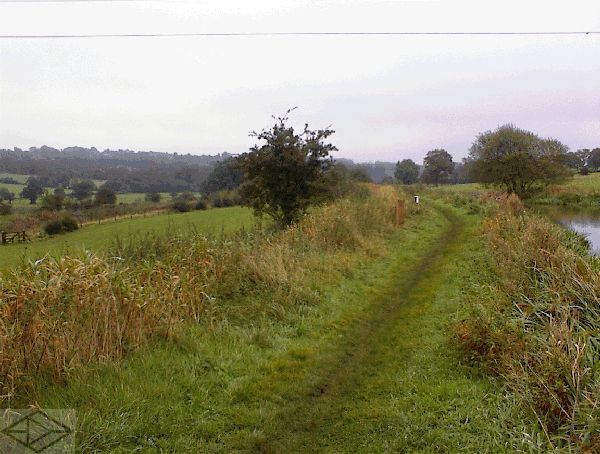
I had approached this point by walking from Park Lane wharf (ref 1). As I had
passed the
first bridge I had a noticed a reed filled depression in the field to the north
next to the railway (ref 3). Initially I though this looked an ideal candidate
for an
old stretch of canal. There was even an ancient bit of hedge which could have
been in the right place for a towpath hedge! However, closer investigation
revealed this depression as of much more recent origin - probably dug by the
farmer to improve drainage. After taking a few more photographs, I drove to
Hazelhurst and approached from the Denford direction.
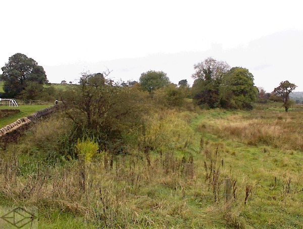 After walking under the aqueduct, and approaching the bottom lock (ref 10), I
was struck
by a level hedge which ran away into the distance towards a point level with
the site of the top lock (adjacent to ref 9). This hedge can just be seen in
the accompanying
photograph -
but is much clearer on the ground. This hedge - or rather its remains and a
fence - are on the top of a bank which contains a feeder stream, which enters
the canal just below the bottom lock. This is the same feeder, following the
same
route, which can be seen on the old OS map above and is marked in orange on the
aerial map. If you have ever walked any
canal feeders, you will know how minimal their banks are. This one is not it is
big enough to take a towpath - and I am convinced that this section of the
feeder is in fact the original route of the canal which has then had the most
recent line of locks built within it. I had often noticed previously how 'built
up' these locks are, compared with the surrounding ground, and re-using the
original line in this way would of course
minimise land purchase costs.
After walking under the aqueduct, and approaching the bottom lock (ref 10), I
was struck
by a level hedge which ran away into the distance towards a point level with
the site of the top lock (adjacent to ref 9). This hedge can just be seen in
the accompanying
photograph -
but is much clearer on the ground. This hedge - or rather its remains and a
fence - are on the top of a bank which contains a feeder stream, which enters
the canal just below the bottom lock. This is the same feeder, following the
same
route, which can be seen on the old OS map above and is marked in orange on the
aerial map. If you have ever walked any
canal feeders, you will know how minimal their banks are. This one is not it is
big enough to take a towpath - and I am convinced that this section of the
feeder is in fact the original route of the canal which has then had the most
recent line of locks built within it. I had often noticed previously how 'built
up' these locks are, compared with the surrounding ground, and re-using the
original line in this way would of course
minimise land purchase costs.
So, how far did this feeder go? Well the old OS map shows it passing under the
railway and westward toward Park Lane, just below tha large '&' on the map. It
is not clear from the map what the source of this water is. However it does
interconnect with numerous streams and so it seems reasonable to assume that
the original canal was also fed somewhere below
its
bottom lock in a similar manner to the present route today. So, where were the
original locks?
I believe the original bottom lock was sited under the present railway line at a point (ref 4) directly to the north of the word 'Trent', the middle lock was where I found the reeds and the new excavation (ref 3) and the original top lock was to the north east of Park Lane (ref 2).
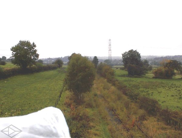
 My reasoning is as follows. The following two photographs are taken from the
railway bridge adjacent to the
first canal bridge west from Hazelhurst Junction (ref 7; ie just east of the
word
'Canal').
The first looks east and the second looks west.
My reasoning is as follows. The following two photographs are taken from the
railway bridge adjacent to the
first canal bridge west from Hazelhurst Junction (ref 7; ie just east of the
word
'Canal').
The first looks east and the second looks west.
Just to the left of the railway in the first photo, and extending into the
distance, is a flat area with two large trees on its edge (ref 9). I believe
this is
part of the original infilled canal line. It is at the same ground level as the
feeder and, I am reasonably confident, at the same level as the canal bank
level at Denford. The flood water in the valley was static and was therefore
very useful to confirm these levels.
 Looking west, in the mid distance, to the right of the railway is a similar
flat area demarked by two lines of trees and fences (ref 6). This is also at
the same
level. As with the previous photos all this is a lot clearer on the ground!
However, do not take my word for it, look again at the old OS map, and then at
the aerial image and you will see that both these areas curve out from, and
back toward, the railway line.
Looking west, in the mid distance, to the right of the railway is a similar
flat area demarked by two lines of trees and fences (ref 6). This is also at
the same
level. As with the previous photos all this is a lot clearer on the ground!
However, do not take my word for it, look again at the old OS map, and then at
the aerial image and you will see that both these areas curve out from, and
back toward, the railway line.
Does this remind you of anything? It should. Look again at the second Hadfield diagram above. He shows the railway wiggling back and forth across the line of the old canal. This cannot be right. The railway plainly does not 'wiggle' - and could not because railway curves need to be smooth. However the canal could wiggle, and so if we take Hadfields diagram as diagrammatical then what he suggests is what there is still a suggestion of on the ground - that the canal wiggled to the north of the railway at two points.
So, let us assume that the feeder originally entered the canal at, or near, this railway bridge, that the bottom lock was under the present railway, then where were the canal remains and the middle lock? I decided to look again at that reedy depression I had previously discounted south of the railway half way toward Park Lane. It looked like a canal, it even had a short bit of bank betweeen it and the railway with a straggely bit of hedge. Surely this had to be it? But what about the new excavation? Then suddenly it hit me, the excavation didn't go anywhere, but some relatively newly laid hardcore lead a farm track across a field. What I believe has happened here is that the farmer, finding some old brickwork in his field has 'robbed it' (in the archaeological sense) to resurface his track. This old brickwork was the lock remains and the new excavation was the original lock site. The levels were about right for the middle lock, so it all fitted!
So what about the top lock? I believe this was immediately to the north east (ie downstream of Park Lane bridge at, or near, the site of the current long weir (ref 2). It would make sense for the canal company to use an existing water route for this overflow
I have heard it suggested that the old lock was the other side of the bridge and to the north side of the lock house. I don't go for this at all for the following reasons.
Chris Deuchar: Wednesday, January 22, 2003