The Wolfampcote Loop
After a brief sortie from the 1997 Braunston Show, further investigation was
obviously needed - in particular as to
whether the aqueduct was still standing. In 1997, after crossing the puddle
banks and following the west end of
the loop, it became unclear after a few hundred yards which way to proceed so
in 1998 we started from the east.
In 1997 we had also walked, on our return, the track from the remains of
Wolfampcote Priory across the fields to
the A45 bridge by the Mill House pub/restaurant. The line of the old canal can
clearly be seen along here until the
point where it disappears into the railway embankment. Ironically the, now
closed, railway was built
after
the canal
became disused and so there is no bridge, and little to be seen on this
section, so in 1998 we took a different route.
Across the road from the former Nursers yard - originally part of the loop but
now Braunston Marina - a lane leads
up a steep hill. From this a footpath leads due south (ie through one of the
Show car parks). This provides some
spectacular views and the aqueduct site is visible across the valley in some
trees and scrub.
 Eventually the footpath reaches a track which, if you follow it downhill to the
right, leads you right to the aqueduct.
Yes it does still exist - as you can see in
the accompanying photographs. The
main aqueduct has two arches but there
is a third side arch on the eastern side.
About 3m (10ft) has fallen away on the
southern (ie upstream) side and about
6m (20ft) on the north - but there is still
a substantial bank remaining. The
northern end of the arches must once
have been curved to follow the line of
the river. This section has now
collapsed but the invert and line of the
walls are still clearly visible underwater.
There is also evidence of a former
byweir from the navigation. The canal at
the top of the bank has been infilled and
the aqueduct now carries a track and
serves as a bridge across the River
Leam for the farmer.
Eventually the footpath reaches a track which, if you follow it downhill to the
right, leads you right to the aqueduct.
Yes it does still exist - as you can see in
the accompanying photographs. The
main aqueduct has two arches but there
is a third side arch on the eastern side.
About 3m (10ft) has fallen away on the
southern (ie upstream) side and about
6m (20ft) on the north - but there is still
a substantial bank remaining. The
northern end of the arches must once
have been curved to follow the line of
the river. This section has now
collapsed but the invert and line of the
walls are still clearly visible underwater.
There is also evidence of a former
byweir from the navigation. The canal at
the top of the bank has been infilled and
the aqueduct now carries a track and
serves as a bridge across the River
Leam for the farmer.
 The River Leam you may remember was
one of the rivers worst affected by the
severe 1998 Easter floods. There were signs
of this still visible at the aqueduct. The
aqueduct must have acted as a partial
dam, as flood debris was visible some
six feet above normal water level and the
arches, but this is barely visible in the
photographs. The most surprising though
was the heap of rubble just downstream of
the side arch. At first we thought this was
just something dumped by the farmer then
we noticed the significant pebble content
and the unusual deployment and we realised
that this was actually old aqueduct brickwork
which had been scoured and deposited by
flood water. The brick sizes confirmed this -
revealing the amazing power of the water
flow even this far upstream at the time of the
floods!
The River Leam you may remember was
one of the rivers worst affected by the
severe 1998 Easter floods. There were signs
of this still visible at the aqueduct. The
aqueduct must have acted as a partial
dam, as flood debris was visible some
six feet above normal water level and the
arches, but this is barely visible in the
photographs. The most surprising though
was the heap of rubble just downstream of
the side arch. At first we thought this was
just something dumped by the farmer then
we noticed the significant pebble content
and the unusual deployment and we realised
that this was actually old aqueduct brickwork
which had been scoured and deposited by
flood water. The brick sizes confirmed this -
revealing the amazing power of the water
flow even this far upstream at the time of the
floods!
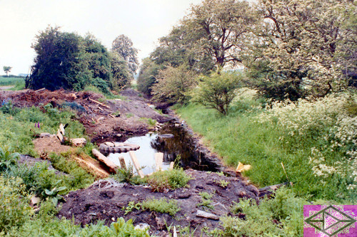
To the east, a depression in the ground still
marks the canal bed heading back towards
the railway - and Nursers. To the west, a
short section, used as a dump, still contains
black water. Continuing westwards a
bridleway leading back toward Wolfampcote
Priory parallels and then crosses the line.
Little then remains, apart from the former
towpath hedge, for about Ẅ mile until a boggy channel reappears approaching the
former Great Central Railway
embankment. A short infilled section, a perfectly preserved section and then
complete obliteration all the way to the
other railway follow.
 At this point, the Great Central
crossed the former railway line
through Braunston but the
embankment of the former appears to
have been used to fill in the cutting of
the latter and an enlarged field is all
that remains. To the north and east of
the former crossing though, the canal
emerges and has been recently
dredged. There is even a fully dredged
winding hole! This has all been done
for anglers who fish the last 1/4
mile back to the new main line past
what is known as Wolfampcote Manor
on some maps - but just appears to be
a large farmhouse. On this section
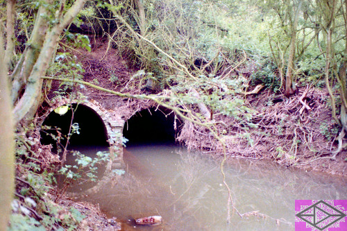
also, is the site of the former 50 yard
Wolfampcote Tunnel, but this has
either been infilled
or
has been
demolished and replaced with a pipe.
At this point, the Great Central
crossed the former railway line
through Braunston but the
embankment of the former appears to
have been used to fill in the cutting of
the latter and an enlarged field is all
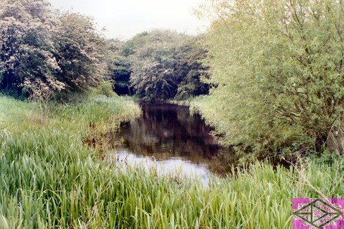
that remains. To the north and east of
the former crossing though, the canal
emerges and has been recently
dredged. There is even a fully dredged
winding hole! This has all been done
for anglers who fish the last 1/4
mile back to the new main line past
what is known as Wolfampcote Manor
on some maps - but just appears to be
a large farmhouse. On this section
also, is the site of the former 50 yard
Wolfampcote Tunnel, but this has
either been infilled
or
has been
demolished and replaced with a pipe.
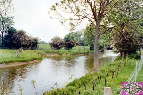
This last 1/4 mile was reputedly the
last to be used commercially (apart of
course from the section now in
Braunston Marina) to take coal to the
hamlet of Wolfampcote. This
presumably explains the winding hole
already referred to. Most of this area
also is free public access.
Ambiguously, the "end" signs at the
track by Wolfampcote Manor refer to
this freedom not the separate right of
way which exists back to the bridge
over the mainline. To the south of the
railway though, the footpaths already
referred to are the only rights of way
so permission should be sought to
access other sections.