![]() Click for:
Click for:
Deuchars' Home Page
Walks Index
|
The Derbyshire Portway
Across the
Andes
Pennines by
Frog
Pack Horse?
Walks & Explorations: A rough, illustrated, guide.
By clicking the icon in the top left of the map window, you can select/deselect
other options to view or click the icon top right to view full screen. 'What3Words' addresses are given for our start and finish points.
|
|
The
photos for this map
are also viewable in album form, section by
section, linked below, following the progression of the walk.
You can also 'right-click' and
download copies of the 2025 route files.
.KML HERE
or
.GPX HERE.
Tracklogs/.GPX files for the individual sections can be found below along with popup altitude profiles obtained from
bikehike.co.uk
|
|
The principal route is shown in blue with alternative routes, and additions, shown in
turquoise or
green
.
I was unaware of this ancient pathway until I saw a program on tv, featuring
Tony Robinson walking Britain's ancient tracks. The route is unusual because,
as he presented it, the south end was a short distance from my home and
terminated at the north end at Mam Tor, in the Derbyshire Peak District some 60
miles away.
Further research revealed that, whilst the route is 'speculative' in some
areas, there is no doubt that such a pathway existed. In his book, Stephen
Bailey (see below) puts forward a good case for the Portway having originally
started by the Trent at Nottingham. Similarly, he suggests that it continued
at the northern end, from Hope Cross, over the Snake Pass, using a route
which subsequently became 'redeveloped' as a Roman road.
The foremost thing to remember here is that the Portway
predated
not only the Roman roads, but many of the towns and villages we take for
granted today. So its avoidance of settlements such as Bakewell, Matlock,
and originally Wirksworth, must not be seen as surprising. They simply
did not exist at a time when the Portway first developed as a long distance
pack horse route between Nottingham and Manchester - and all the mines in
between.
Also because of this, it is not surprising that the route changed as time and
patterns of trade changed. So, for example, Stephen Bailey suggests an
alternative, later, route which takes in Wirksworth (turquoise on my map). The
route in blue is primarily Stephen Bailey's suggested 'original' route.
The indicated route is largely based
on a GPX file for the Hemlockstone to Mam Tor section supplied by my
friend Ken Brockway (to whom I am indebted) and extended by me to Sneinton
Hermitage in Nottingham, at the south-eastern end, and Hope Cross, and thence
Glossop, at the north wester end. I have added other alternatives (in
green) because either, they involve less road walking or, I perceive them as
viable original alternatives - or both. I have also added many other ancient
locations, such as standing stones, either because they are again in Stephen
Bailey's book or because I found them at
www.megalithic.co.uk
- or both! As above, the colour scheme represents those referenced by Stephen
Bailey in blue and those from elsewhere, by me, in green. The brown markers
are for the photo locations which may also be viewed en masse in the daily
albums (see below). All photos are by C&J Deuchar unless otherwise credited.
GPX files for each section, based on our actual tracklog, may be downloaded fromm the links in each section.
I have found a number of websites & publications with more information on the
walk route(s) and history. The following are just samples.
Follow these links for further information:-
All links should open in a new tab.
For a historic map of the area, follow this link and then adjust the
transparency on the slider scale to view the present day appearance (You will
need to zoom and track to find the section of interest):
Click Here for Historic Map
The best starting point is probably
this Wikipedia entry
- but this does not acknowledge the whole route.
Stephen Bailey's book may be obtained from numerous sources such as
Amazon
"The Old Roads of Derbyshire" ISBN-10: 1789018439 ISBN-13: 978-1789018431 and
is largely an expansion of an earlier book which dealt exclusively with the
Derbyshire Portway. The newer book includes much interesting material on road
development and additional Derbyshire walks.
|
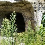
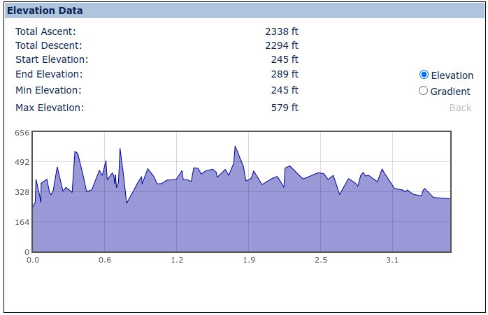
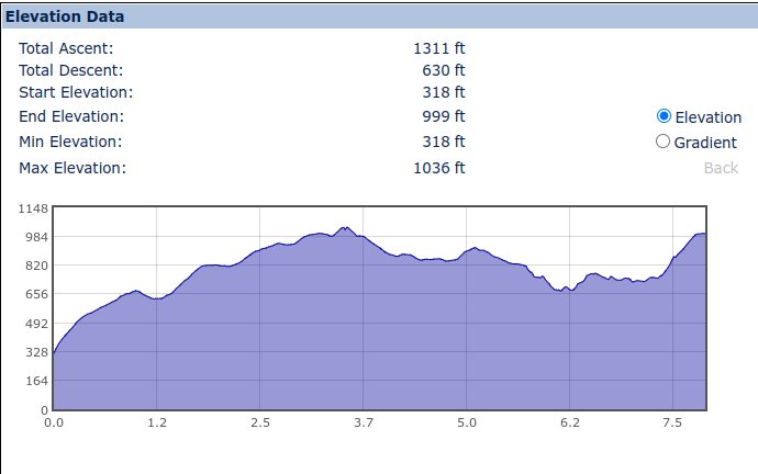
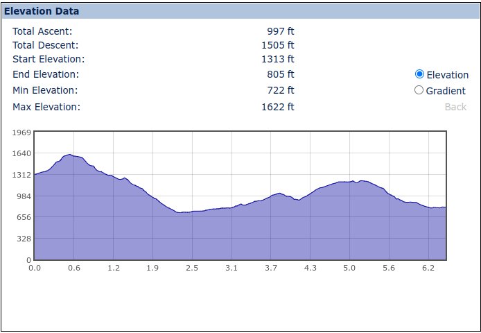
Day 1: Sneinton Hermitage to The Hemlockstone - 7 miles. (wizard.gazed.arch to sleeps.member.blocks)
The old
'hermitage' caves
are there, right by the side of the road, and so,
after viewing the
Sneinton Dragon,
we proceeded via Fisher Gate and Pennyfoot
Street to cross to Malin Hill directly opposite. From here there was a dilemma
because we were previously aware that there had been three routes. Either,
turn right and ascend to St Mary's church, and High Pavement via Hollowstone,
turn left and ascend via the Long Stairs (currently closed) or proceed a short
way up Malin Hill and then turn right up the Short Stairs. In the event, all
were probably wrong because, straight ahead, a fourth route, Malin Hill, turns
into an old cobblestone path, hanging on to the side of the rock, and emerges
in Commerce Square, right by St Mary's church. This is the way I would take a
packhorse train - without doubt.
Heading west via High Pavement, Low Pavement and Castle Gate, followed by a
brief right and left turn round the castle, took us to Lenton Road - ie 'the
road to Lenton', quite literally - through the fine private Park Estate. On the
left there is Hermitage Walk - which once lead to the second hermitage on the
route but is now occupied by modern housing. However, many old cave remnants
can still be seen at the rear of premises on Canal Street - which runs parallel
to, but below, Lenton Road. A short jitty then leads out of the estate into
the, ironically named, Park Road and public roads again lead us downwards
towards the former Grove pub - currently closed. In turn, Grove Road leads to a
low railway footpath underbridge and onto Lenton where we turn right onto
Lenton Lane.
After a brief sortie to check out the
Lenton Priory
remains by the traffic
lights, we retreated slightly to take the alternative route to see the other
priory remains before turning right again past the Boat Inn and then across the
main road and walking up the east side of the River Leen. Crossing the Leen by
the back of QMC we continued up the west bank path to Derby Road. From here it
is far quieter to walk along the service roads on the north side of the main
A52 Derby Road, cross the ring road, and then only exit onto the main road at
the top of the rise.
Up to this point, the route had been a surprisingly pleasant way to cross the
city but the next mile, alongside the heavy traffic, was much less so but
was punctuated by a brief detour, into
Wollaton Park,
to visit Arbour Hill where there is probably
the largest and most magnificent oak tree I have ever seen.
Finally, leaving the A52 and housing behind, there is a steep rise to regain
the high ground
along the ridge. From here to Bramcote all is quite peaceful and there are a
variety of paths which meander through the trees. Probably it was always so!
Eventually reaching Coventry Lane (adjacent to the somewhat sinister looking,
and heavily protected 'Plymouth Brethren Meeting House'?), we turned south for
the short roadside walk to Bramcote Hills Park car park and the Walled Garden -
opposite the Hemlockstone itself.
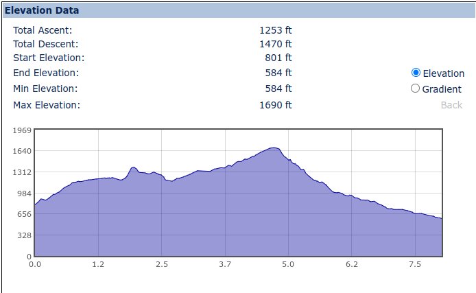
Day 2: The Hemlockstone to Morley - 8 miles. (to large.unwind.rebel)
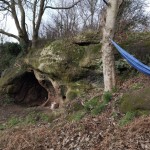
The Hemlockstone
is of unknown origin. As a child I was told it was a volcanic
plug but other theories abound - including a left over 'stack' from quarrying.
The most amazing thing is that no one seems to know for sure! From here it is
an easy walk along Hickings Lane in Stapleford and then across the county
boundary at the River Erewash. Shortly after, the longest railway footbridge I
have ever known, crosses what used to be the northern part of
Toton Sidings
-
but which is now a silver birch forest. Across the Erewash Canal, and Ilkeston
road, a good path leads up to Sandiacre Church. This has a very gradual
gradient and stone walling at the sides - suggesting it was once of much
greater significance than it is now.
Another road section finally leads out of the urban area and up to the heights
of No Man's Lane where excellent views are seen to north and south. A bit of a
zig-zag and field paths continue along the ridge until the descent in Hermitage
Wood - where the stone
hermitage
itself can be found - a scheduled ancient
monument. Dale Church is almost unique in being 'semi-detached' to the
adjacent large (and growing) house. Leaving Dale, a footpath detour avoids the
road around a second Arbour Hill on the route, before crossing the main
Ilkeston to Derby Road and onto Hagg Lane.
Easy walking from here on, Hagg Lane turns into a farm track before reappearing
as Dale Road in Stanley village, just after the site of the former Kilbourne
Colliery. Following the Stanley Brook, the path continues westwards and
crosses the route of the former Great Norther Railway and continues until
meeting Church Road on the outskirts of Morley. Despite only being the access
to a handful of dwellings, this road too has considerable engineering features
(walled sides, drainage and a raised pavement) which seem out of all proportion
to its current usage.
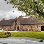
The Morley Butter Cross may now be found inside
Morley Church
yard - which in
itself is one of the best kept churchyards I have ever seen. It also has a
separate chapel for the former Morley family.
Day 2a: The Hemlockstone to Stapleford - 3.6 miles.
After completing the whole walk, I decided to look for another route for the Hemlockstone to Stapleford section. Following Hickins Lane did not 'fit right'
in the concept of a ridgeway and, after finding no less than three interesting and potentially ancient items on the hills to the south, this alternative is suggested.
From the Hemlockstone, a path leads south through Bramcote Hills Park and, at the rear of the leisure centre car park, is Crow Hill on the south-west edge of which sits
a standing stone.
I suspect this may be the last remnant of a complete circle of stones around the hill top earthworks. It has a hole through in the way of many similar stones along old pathways.
From the stone, across the A52 from the leisure centre, there are a number of paths though to, and beyond, Kings Playground which lead up the hill to a footpath along the ridge. This path has magnificent views to the
south beyond East Leake. To the North one can see not only Crich Stand but also, more relevantly, Alport Height. Following this path, a farm access bridge takes us across the A52 again.
Beyond this, the footpath continues straight ahead towards Sandiacre church spire (which we pass later in Section 2) but firstly through Stapleford Cemetery. Herein, a diversion to the north side
may be possible to Bob's Rock. This is mostly famous for once being the place, in 1774, from which John Wesley, the founder of Methodism,
addressed the people of Stapleford. Public access is now difficult due it being taken over by trail bike activity.
This is a shame as there is a shallow cave there, in what was most recently used as a sandstone quarry. Was this once another hermitage?
Another footpath leads from the south west corner of the cemetery and down into Stapleford where, after passing along another short footpath, we can access
The Old Cross, in Stapleford St Helen's churchyard,
- across the road from the pub of the same name. From here it is only a short way to rejoin the previous 2a section at Mill Road.
Alternatively, you can return to the start via Hickins Lane to complete a circular walk of just over 5 miles.
Day 3: Morley to Blackbrook - 8 miles. (to swoop.packet.unhappily)
Some nice field walking to start with on this stretch; good paths interspersed
with stiles and the notable
Morley Mound
which is of ancient but indeterminate origin! There are a lot of path options
around here but we chose to view the fine almshouses in Morleymoor before
heading north towards Morleymoor Farm via some old clay pits - now overgrown
with trees. Shortly after leaving the farm, and its fine garden, we crossed
the route of Roman Ryknild Street - without noticing - and skirted round, and
through, the back gardens of Brackley Gate to emerge at a fine view towards
Kilburn in the north.
Not far beyond, after passing an equestrian establishment(?) featuring
something rather smaller than the Lothian Kelpies, we reached
Horsley Park and Castle
. This area is an absolute gem where silver birch trees, and oaks, have
grown over the former castle site and associated stone quarries.
Descending towards Coxbench (previously 'Tanton Cross'), and the A38, we passed
some rather fine kennels,
with viewing portals in their fence for both humans and canines. The access to
the former quarry leads down to the re-sited
St Anthony's Well
at Coxbench and our
route under the A38 and thence crossing the routes of the former
Little Eaton Gangway
and the standard gauge line to Ripley. Here we took a look at the
'repurposed' Coxbench/Holbrook Station before taking the road to Holbrook
itself. This road is actually called 'Portway'!
Reaching the top of the ridge at Holbrook there are some fine views, east and
west, before descending to Makeney (and the Holly Bush Inn!) and thence to
Milford - although the footbridge is no longer publically accessible since the
garden centre and Millhouse pub have both closed.
The climb up Sunny Hill out of Milford is remarkably steep but the views are
rewarding - notable for the quickness with which it overtakes the height of the
former mill chimney! At the top there is not only a railway tunnel air vent by
a golfing green but also the bizarre
Stephenson's tower
which was apparently
built as an aid to railway alignment during that construction.
The ridgeway from here along North Lane gives outstanding views to either side
initially but then, after passing the former WWI rifle range wall, of Belper to
the
north. This road is laid with large stone cobbles, many of which have sadly
moved and allowed considerable erosion. This is sad - but at least means that
passing wheeled vehicles cannot spoil a good walk!
After a slow descent to Farnah Green, the path again took us round the back of
a few gardens before spitting us out at a junction of paths and then heading
towards the woods above Lumb Grange. Heading north, it was only a short way
along Lumb Lane to cross the Lumb Brook before meeting the A517 at Blackbrook.
A brilliant day's walk.
Day 4: Blackbrook to Middleton Top - 8 miles. (to belonging.adopters.willing)
Climbing the rough Longwalls Lane from Blackbrook, we travelled along a very
similar road to North Road on the previous day - ie a rough, eroded cobbled way
between two stone walls about 30 feet apart. In this case though, the way was
rather more heavily overgrown - but readily passable and with excellent views
to either side. The last part of the lane is tarmaced and meets with other
routes at the former site of Knave's Cross. After another couple
of hundred yards we were off into the fields, en route passing near Crowtrees
Farm, towards
Alport Height.
The views were continually outstanding, with Crich
Stand visible to the east and Ratcliffe Power Station to the south. Good field
paths, but some indifferent stiles, lead to a junction with three lanes on the
approach to Alport Height. Back Lane leads round to the entrance to the Height,
from which 360 degree views extend as far as the
Long Mynd in Shropshire,
63
miles away! Fantastic!
At this point in our walk, we could see incoming rain clouds which
unfortunately blotted out the sun for the rest of the day. They also spoiled
some of the views, and photos, but I will endeavour to get some improved images
at some point for today's album. Some pleasant quiet lane walking led us past
the huge Hardhurst Farm and to Breamfield Lane - from which the view of
Wirksworth and its quarries is unparalled - at least in good weather!.
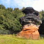
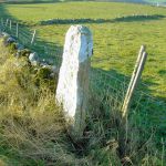
Near the staggered crossroads at Wirksworth Moor there is a
standing stone,
of arguable provenance, in
the field. The route next takes us down through pretty Little Bolehill and
thence via a footpath to Bolehill itself on the north-eastern corner of
Wirksworth. At this point, we need to turn left onto the former
Cromford & High Peak Railway (CHPR)
but to do so means going through the arched bridge,
right onto a bridleway and thence onto the trackbed. There is a another
potentially useful car park here at
Black Rock
- the last place in England to
have had wolves - allegedly. I say allegedly because there has been talk of
reintroduction and, if a blood curdling howl I heard in the 1970s on a foggy
evening a little to the east was anything to go by, then they never went away!
From here it is only a short walk along the trackbed to the
Middleton Incline
and another good car park, visitor centre and facilities. There is much of
interest along here - bits of old railwayana and the, still functioning,
Steeple Grange narrow gauge railway
built along the trackbed of a former CHPR
quarry branch. There is also some inexplicable, and inexcusably confusing
pseudo-railway sculpture, whose sole purpose seems to have been to have used
money that would have been better spent on the infrastructure upkeep or
restoration.
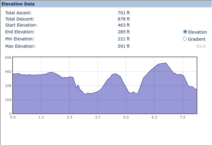
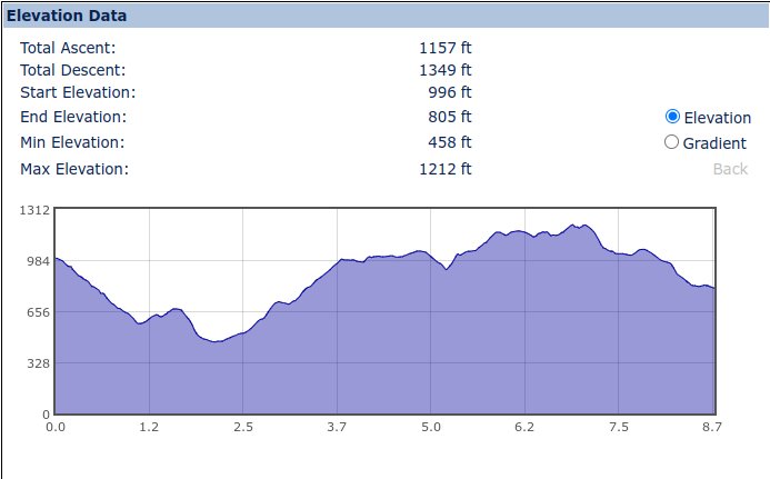
Day 5: Alport Height to Grangemill (via Wirksworth & Middleton Top)- 8.75 miles (with deviations). (unfocused.lively.hillside to slippery.waffle.procedures)
This was our most energetic day so far. Having skirted
Wirksworth
on our previous day via the northern route, this (later) route goes via the
town itself. The descent from Alport Height was quiet and easy along narrow
roads with only a hedge-cutting tractor to pass by. On Taylor's Lane there is
supposedly Folly Well in an adjacent field but we could not access it -
however, the
name features in several local places. This whole area is very attractive -
especially around Holehouse and Doveswood Farms, the ford across the brook and
along Pratthall Lane.
Gorsey Bank is an attractive suburb of Wirksworth, with the stone-built
Providence Mill and other buildings of note. Our route crosses what is now the
Ecclesbourne Valley Railway
- a restored line with much of interest in Wirksworth itself.
From Wirksworth itself (aka 'Stone Town'), rather than follow the road up
towards Middleton Top, we followed a more direct, traffic-free route, along a
series of footpaths through the disused
quarries and then fields to reach the Cromford & High Peak Railway (CHPR) just
west of where we finished the previous walk. To close the gap we followed a
farm track eastwards and then looped back along the old railway to the same
point before proceeding north-westerly past Moor Farm.
From here we descended yet again towards Arm Lees Farm, and under the former
CHPR Hopton Quarries Branch, before ascending again to go around the north side
of a, still active, quarry and its huge wind turbines. Leaving the quarry
behind, the way should have got simpler but the footpath directions are in a
bit of a
mess and we struggled to find the correct paths to get us to Harborough Rocks.
Some stiles are definitely missing (!) but we found our way to
Harborough Rocks
eventually and enjoyed the magnificent views all around from the High Peak in
the north, to Ratcliffe Power Station in the south, beyond Carsington water in
the middle distance. Here also, amongst other industrial remains, may be found
a former cave dwelling, a chambered cairn and some more recent memorials. The
rocks appear to be well used by climbers.
Back on more obvious footpaths, we descended past New Harboro Farm and onto a
decent track for most of the route to Grangemill. The last part of this
demarked bridleway was somewhat muddy but gave interesting views of the
quarries here and the
Via Gellia
below. Somehow we missed a path towards Ible which, on consideration, then
leads onto other paths following a route which may have been a more serious
contender for being the Portway? (See Day 5a below)
Day 5a: Ible & Grangemill Variants - 1.8 miles
After the pevious excursion, I decided to explore further round Grangemill &
Ible to check out the alternative routes I had put on the map. A delightful
short walk took me up the field path deviation from Tophill Lane and then I
returned via Whitelow Lane and 'the middle of Ible' before crossing the Via
Gellia at 'The
Lillies' and then back down to Grangemill. Not only did the latter part of the
route feature a couple more very large stones, hitherto used as gate posts,
which may originally have been 'standing stones' - or way-markers - but this
route also uses a rather splendid, evenly graded, zig-zag path on the east side
of the Via Gellia valley near to the former Lillies pub. This path was
definitely over-engineered for just the historical handful of Ible residents to
get to the pub! I am sure this once had a much greater purpose?
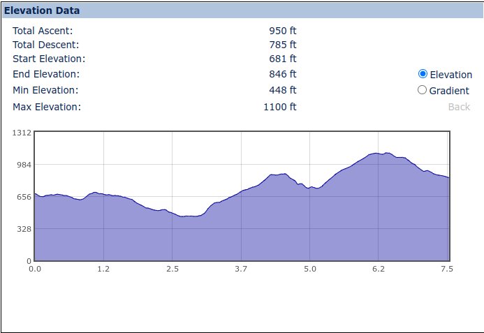
Day 6: Grangemill to Conksbury (Medieval Village) - 7.52 miles (with deviation). (to giants.warthog.tricky)
This was a good day with relatively easy walking, several ancient sites -
varying from mines to hermits caves and a stone circle - and some gorgeous
scenery.
Leaving
Grangemill,
the narrow Grange and Tophill lanes ascend rapidly - but
not quite so rapidly as the alternative footpath straight across the fields -
eventually reaching a common point above
Ible where four lanes meet. Turning northwards at this point, Whitelow Lane
continues northwards and then splits. For the next couple of miles there is
ample evidence of mine working. This is the western edge of the former great
lead mining district of Bonsall
- in which some of my ancestors once toiled.
Taking the western track branch, a straight line of stiles at field boundaries
leads eventually to Bonsall Lane which is crossed to reach a high point above
Winster.
It is only a short descent, along Occupation Lane, now part of the
LimestoneWay, to the
main B5056 at the
Winster lead ore store
- an ancient version of a 'night safe'. Continuing along Islington Lane (aka.
the Limestone Way), with Winster to the east, the path descends gently, past
the former Portaway Mine (one of two near here), towards the lower land before
the striking
Cratcliff Rocks
and
Robin Hoods Stride.
Here another ascent,
alongside what appeas to be an old hollow way, leads to open access land where
the rocks are worthy of exploration, not least because there is yet another
hermit's cave! (Although I haven't found the 'proper' one yet...)
Also here is what is left of the former
Nine Stones Close
stone circle (now just 4 stones) on private land. This whole area is worth
some exploration. There is a separate standing stone, removed from the circle
and now in use as a gate post, along with a possible barrow. On reaching Cliff
Lane, there is another good view of the stones before a descent through the
woods on the way to
Alport,
near
Youlgreave.
Ths is another very quiet lane with good
views around - notably towards Stanton-in-the-Peak where there is the
Nine Ladies
stone circle and other ancient monuments.
Alport is a bit of a dream village, scenery wise, although I suspect it can be
rather bleak in winter in the depths of its narrow valley. From here, another
Dark Lane leads northwards past the signs of other former mining - most notably
the
Raper fluorspar mine.
The Portway continues along the centre of this broad
ridge between Over Haddon and Haddon Hall but we bore slightly left to visit
the site of the former
medieval village of Conksbury.
In the intervening
fields there appears to be some terracing - which too may be medieval in origin.
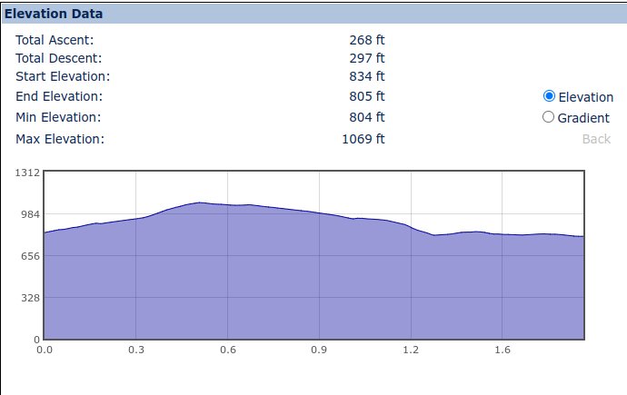
Day 7: Conksbury to Wardlow Mires - 7.5 miles (Oct 2021) (to rubble.avoiding.pronouns)
Rejoining the Portway at the top of the hill above Conksbury, rather than the public car park we finished last time,
the first half of this walk is an undulating mixture of road and easy footpath along the ridge to the south west
of Bakewell. Like the original route 'around' Wirksworth,
it is difficult to think that the town did not even exist
at the time the Portway was initially walked. In fact, the town is still almost invisible from the route today.
Returning to the road, the route descends into the valley via Crowhill Lane and then runs alongside the busy A6
- but only for a short distance before turning off on the old road, and over the old bridges, to the attractive
village of Ashford-in-the-Water. This was also the home of quarrying of the decorative
Ashford Black Marble until the 1900s -
we had noticed the blackness of some of the stone we were walking or climbing over.
This village has at least one of everything you need from pubs, shops, cafes,
churches and toilets! Our route then has a couple of options, and we went through the village and took the steps up the side of the valley, whereas
a more 'correct' way might have been via Greaves Lane, Hill Cross and Vicarage Lane, a little to the north.
However, both routes meet and follow Pennyunk Lane to its very end, and beyond, before turning northwards to
skirt the eastern side of Fin Cop which was the site of another iron age settlement. A level, pleasant path continues
northwards until the edge of Monsal Dale, where there is a well engineered path which nevertheless has some rather
awkward steps in the descent. Monsal Head is rightly well known for its outstanding scenery, including views of
Fin Cop as well as the famous railway viaduct. Here also is the Monsal Head Hotel and a tea rooms alongside a car park.
From here, the rest of the day's walk is all along a metalled road, past Rolley Low,
Wardlow Hay Cop (you will need to translate this site) also see this
Wardlow Hay Cop and other ancient sites all the way to
Wardlow and Wardlow Mires. There is a lot to see,
including further outstanding views all around and many tumuli and lows (raised mounds of ancient origin) either side.
Tantalisingly, on a clear day, one can just make out the top of Mam Tor - which is the target of the next section.
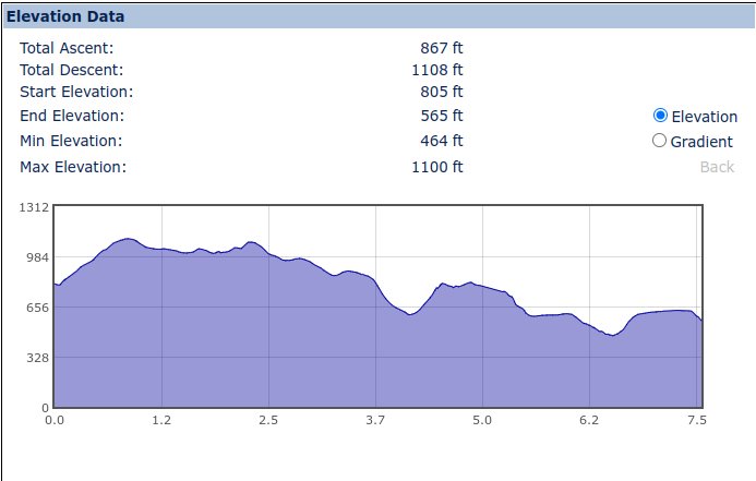
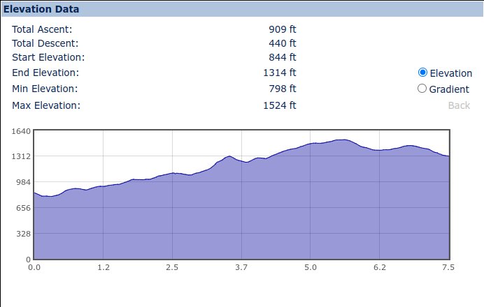
Day 8: Wardlow Mires to Mam Tor - 7.5 miles (Nov 2021) (to domain.rate.expires)
At Wardlow Mires, there is not only one of the best pubs anywhere (The Three Stags Heads)
but also probably the best cafe anywhere - The Yondermann. However,
resisting these temptations, during the covid pandemic, we entered the adjacent farmyard where the footpath is indicated to the left by daubed 'FP' and arrow signs.
Like most of this day's walk the inclines are gentle and in this case we walked up the field and joined a track westwards. This leads to a junction with Trot Lane which
is notable for the limestone outcroppings on either side as well as what appears to be a small private cemetery. At the top of Trot Lane, turn right towards the
enigmatically named hamlet of Windmill. This, thankfully short, stretch of road can be quite busy, so take care avoiding the traffic.
Leaving Windmill behind, the route enters an area known as the Rakes. The origin of this name is obviously an example of the whole raison d'etre for the Portway as
it refers to where a minerals seam reached the earth's surface. Firstly here is High Rake - where relatively modern deep mining was attempted and yet was subsequent
to far more ancients works. Here was a steam engine and a horse gin, both explained through interpretation boards. Continuing onwards is the bizarre spectacle of
Tideswell
Rake, the western end of which was also reworked for fluorspar relatively recently. The two rakes take us forward around a mile and are probably the most interesting section for the day.
Looking north from near the radio mast a farm can be seen with a tree-lined route heading northwards. This is where we will be heading next after a short detour to
accomodate modern rights of way. Once onto this lane, it is northwards for the rest of the day. From the farm track, the route crosses the former Roman road of
Batham Gate before reaching open moorland, from which many more ancient workings can be made out. The most notable of these are more mines named 'Portway'! Then it is back to
more farm tracks, and a few yards of main road, before reaching the foot of Mam Tor.
Day 9: Mam Tor to Alport Bridge - 6.6 miles (April 2022) (to digests.activates.koala)
From the foot of Mam Tor. there is an immediate steep ascent. This is not a problem because there is a good path with suitable steps.
Unfortunately, a major part of the rest of the day turned into some very hard work over clearly defined, but very difficult, paths which resembled stream beds - strewn with rocks and large stones. The views, however,
were outstanding, even if progress was slow.
From the high point of Mam Tor, and its iron-age hill fort, the initial descent towards Hollins Cross is quite gradual along an easy stone-flagged path. The next section down into the Edale valley is very rutted with evidence of powered vehicles.
This was not good but did at least give a good vantage point for watching loaded goods trains struggling up the valley heading west. It also showed evidence of iron stone. No, the Peak District is not all limestone,
there are many other minerals to be found. The short walk along the road was a pleasant change, with virtually no traffic, before we bore left along a sunken, stone sided, path and across a small ford.
From this point on the path is mostly rough stone and difficult walking. There is a bit of a breather from this surface where the path, with a much finer surface, does a steep, sharp hairpin around a pleasant tree-lined valley.
Across another ford we (amazingly) met a farm vehicle (successfully!) towing a sheep trailer over a trackway that we had trouble walking...
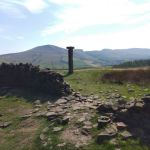
Finally reaching the top of the last hill, and a cross roads with an old Roman road, we briefly turned south to Hope Cross (which still stands) and were rewarded with some excellent views into Edale and back to Mam Tor.
Hope Cross is seen by some as the end of the 'modern version' of the Portway (although some people only get as far as MamTor). It seems probable that the original Portway would not have followed our route into Edale.
A much more likely route - in keeping with the philosophy of staying to the ridgeways - would have been to continue from Hollins Cross along to Lose Hill and then descending to cross the river before ascending again to Hope
Cross. Whilst the second part of this route still has a right of way up toward Hope Cross, the first part, down from Lose Hill, is not a footpath in the modern world.
Heading north again, along the old Roman road, the rock strewn route becomes increasingly mixed with sand. This seemed very strange in a heather landscape. Despite a couple of short sections where the (original?) Roman
road surface can be seen, between stone kerbs, the route once again becomes little better than a dried up stream bed. At least in our case it was dry! It was quite obvious that, under wet conditions, there must be a raging
torrent down here - so pick your weather carefully!
Finally, we reached a point where our route reached a modern track between farms in the hamlet of Alport Bridge. Here there is an Environment Agency construction, which is presumably something associated with the reservoirs downstream.
There is also a modern vehicle ford, and a footbridge, across the River Ashop before arriving at Alport itself and the bridge over the Alport River to which it gives its name.
Day 10: Alport Bridge to Old Glossop - 8 miles (July 2022) (to imply.deflection.palace)
From Alport Bridge, a gate leads up a slight rise through a tree-lined sunken path to a farm track which then diverts the path to the outside of a farm before returning to another sunken path leading steadily uphill.
At this point the walking is good on grass and there are multiple field boundaries as the route becomes more moorland in nature.
There is a bit of a dive and zig-zag around Oyster Clough before a steep climb around some woodland.
This is the first detour from the route of the Roman Road alignment we have been following since Hope Cross in the previous section. Once around the wood, the Roman road descends further to the Snake Road - which would be the 'proper'
route to continue, but rather than walk alongside a busy road we followed the permissive path through Lady Clough woods between the Snake Road and the River Ashop. There are multiple routes through the woods - some better than others!
Exiting the north end of the woods, there is a choice between climbing to follow the Snake Road or continuing on the rising path to meet the road further on. There remains then just a short walk to the start of Doctor's Gate - a Roman Road again -
which will take us all the way to our destination. Parts of Doctor's Gate still show evidence of original Roman paving. Other lengths have more modern stone flags whilst some is either boggy or stony. Suffice it to say that up to the crossroads
with the Pennine Way the way is good but west of this crossing the route is mostly a stony path which is rather challenging, to say the least. However, the final mile or so is farm tracks of a good standard before arriving behind a factory in Old Glossop.
So, why stop here? The answer simply is that the route of the Portway from here into Manchester is simply lost to modern building and and overlain by modern roads, so there seems little point in persuing it further. The only exception would be
to reach the ramparts of the Roman Fort of Melandra (See also Here) at Dinting Vale on the west of Glossop. Whilst worth a visit in its own right, it is, of course, too 'modern' to be part of the Portway!