|
Home Page Walks Index |
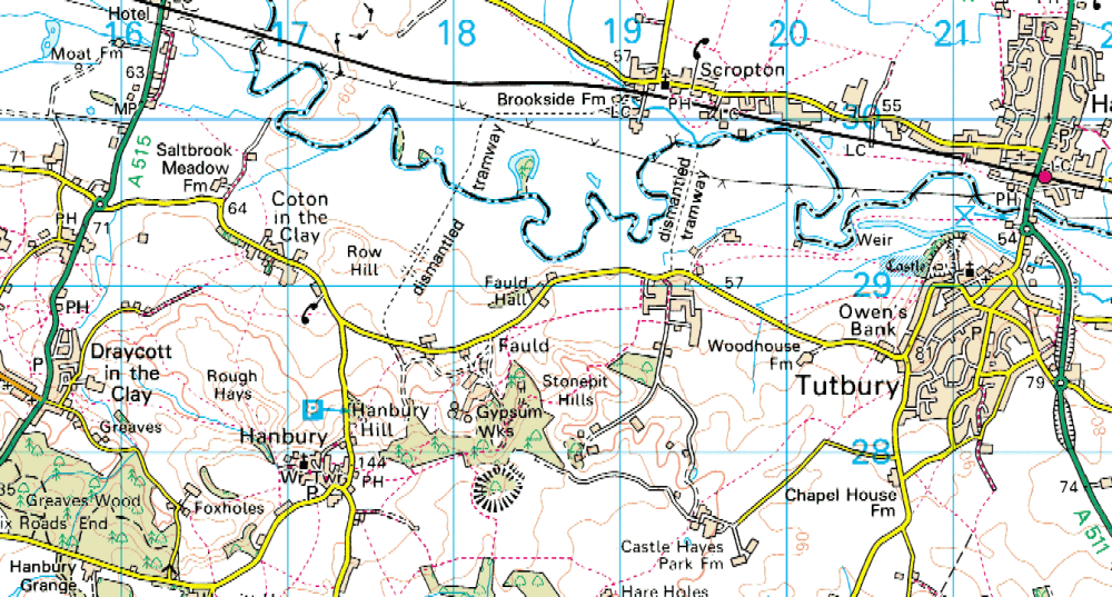
Railway Walks & Explorations - Fauld Crater, Tramways & ScroptonA rough, illustrated, guide to the two former tramway routes into the hill at Fauld, Staffordshire - and what they look like today. By clicking the icon in the top left of the map window, you can select/deselect other options to view or click the icon top right to view full screen.
The Flickr photos for this map are also viewable at https://www.flickr.com/photos/deuchars/albums/72157670509254197
|
|
The tramway routes are shown in
orange
and my circular walk in
green
.
You can right-click and download my walk around Fauld & Hanbury GPX file here for use in your GPS, Sat Nav or phone mapping. You can also right-click and download my walk around Scropton GPX file here First, let us be clear, there were two railways not just one. The first was generally known as the Scropton Tramway (1889-1949) as it commenced by the main line station of that name and then trailed across fields towards the gypsum/alabaster mines at Fauld - below Hanbury and near Tutbury. The history of this tramway seems well documented and mapped (eg see https://en.wikipedia.org/wiki/Scropton_Tramway ). This was a 3ft gauge, locomotive worked railway. However the second railway - the RAF Fauld Depot Railway (1940s to 1958/66 and 1979), closer to Tutbury - led in an almost direct line south from Scropton to what is now an industrial estate but still seems to contain a highly secure area at the southern end - where, incidentally rails remain visible of what was a 2ft gauge railway. It is probable that this started out as a military railway rather than an adaptation of an earlier mineral railway (not linked from the older line). (See https://en.wikipedia.org/wiki/British_military_narrow-gauge_railways Either way, the bomb store is quoted as being in a 'former gypsum mine'. The MoD retain land in the area - most obviously at Faulds Crater when 'Unexploded Bomb' signs still proliferate from what was probably Britains largest ever self-inflicted explosion and is also claimed to be the world's largest ever non-nuclear explosion! (See https://en.wikipedia.org/wiki/RAF_Fauld_explosion ). Whether there was ever a link between the two systems - either at Fauld or Scropton - is unclear - but, given the gauge difference, is unlikely. However, munitions were allegedly transported during wartime, 'on both systems', for storage in the mine workings. I doubt this and suspect some of the confusion about the number, and nature, of the railways into the hill at Fauld was deliberate obfuscation by the authorities. My personal opinion is that the RAF, having decided to utilise the former gypsum working in the hill, wanted their own entrance and built a new tunnel into the pre-existing workings which would then have been isolated from the, then still working, mining area. I have found no map of the RAF railway system that was either contemporary with its construction nor during its working life. All I have found is on a more modern map where a 'dismantled tramway' is indicated. There is not even a true representation of how far this extended toward the hill.
I have found a number of websites with more information on the railway and its
history. The following are just samples.
For a historic map of the route, follow this link and then adjust the
transparency on the slider scale to view the present day appearance:
These websites have a lot more information - especially (ironically) on the military line.
The RAF Fauld Depot Railway
https://www.dailymail.co.uk/news/article-3699468/Forbidden-remains-Britain-s-biggest-explosion.html - Daily Mail article with some excellent photographs of the military railway remains in the tunnels at Fauld. https://www.iwm.org.uk/collections/search?filters[placeString][Fauld%2C%20Staffordshire%2C%20England%2C%20UK]=on - Imperial War Museum photos of bomb storage, two loaded bomb trains and an aerial shot of the crater at Fauld. I believe the two train photos were taken looking in opposite directions from the same vantage point (probably on the same day?) and clearly show the RAF tunnel entrance. In the background of one of these two, a spur can be seen with other rolling stock on it. Beyond the crater in the aerial photo can be seen what looks like a roadway beyond the hill - this is precisely the alignment of the RAF railway into the hill, with the rails either side of the road as described a the link below. This plan of the bomb storage is interesting in several ways - showing the complexity of the tunnels and that the site of the explosion was toward the limit of the tunnels' extent from the RAF entrance. https://www.rmweb.co.uk/community/index.php?/topic/133141-the-bomb-store/ - This railway modellers site is particulary interesting as it gives details of the military rolling stock at a time it was auctioned and includes photographs not seen elsewhere. After the intial pictures, scroll down to the postings from 22-4-2018 for more photos and historic info...
Since the Fauld Explosion...
https://www.theurbanexplorer.co.uk/raf-fauld-detonator-stores-staffordshire/ - an intrepid exploration of the old tunnels.
|
